Leica RTC300 3D Laser Scanner
The Leica RTC300 is a high-speed terrestrial 3D laser scanner that delivers trusted Leica RTC performance in a streamlined, scalable configuration. Built for agile reality-capture workflows, it captures up to one million points per second at ranges up to 85 meters, pairing fast point-cloud acquisition with a calibrated 360° HDR image, so your team leaves the site with a complete, color-rich digital record of the space.


Designed for professionals working across building construction, BIM, and general surveying, the RTC300 is the natural entry point into the new Leica RTC series and a forward step for teams upgrading from the RTC360. It connects field capture, cloud collaboration, and office processing into one continuous workflow built around Leica Cyclone FIELD 360, Hexagon GeoCloud, and Cyclone REGISTER 360 PLUS, helping you reduce return trips and accelerate deliverables.
Fast Capture, Trusted Leica Accuracy
The RTC300 scans up to 1,000,000 points per second and completes a full-dome scan with a spherical HDR image in roughly two and a half minutes at 6 mm resolution at 10 meters. Every measurement is driven by Leica's high-dynamic time-of-flight engine with Waveform Digitising (WFD) technology, delivering 1.5 mm 3D point accuracy at 10 meters and 10″ angular accuracy. Automatic self-calibration runs during normal operation, so the scanner maintains its precision without targets or manual setup steps.
True-to-Life Color in 30 Seconds
An integrated 72 MP, six-camera system captures 432 MPx of raw HDR data and renders a calibrated 360° × 300° spherical image at 174 MPx resolution. A full tone-mapped image is produced in just 30 seconds in any lighting condition, with automatic exposure and white balance, giving you point clouds that are both dimensionally accurate and visually faithful for documentation, modeling, and client review.
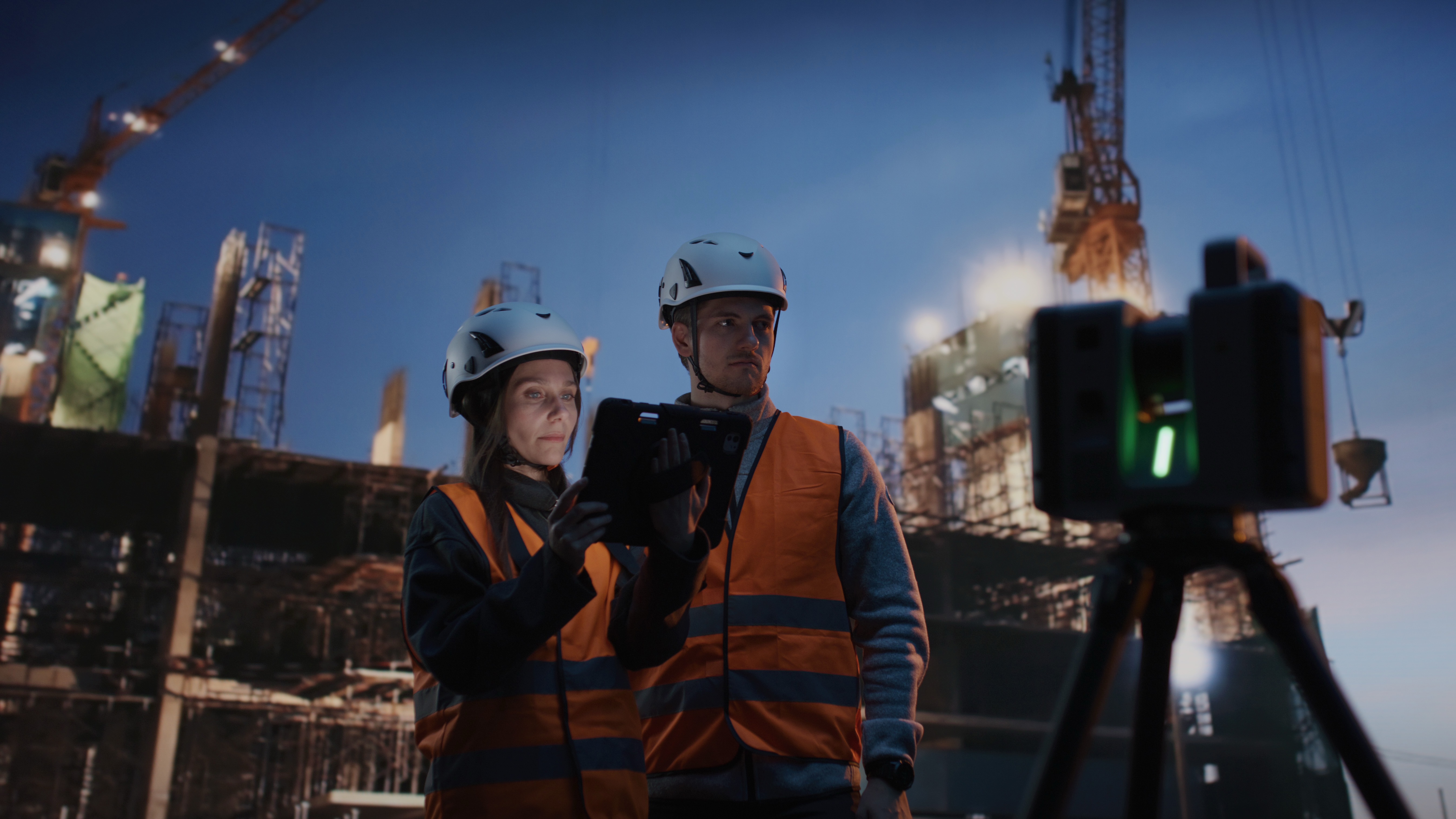
Register While You Scan
The RTC300's Visual Inertial System (VIS) tracks the scanner's position and movement in real time, automatically pre-registering scans on site. Combined with on-board tilt compensation, GNSS, and a shock sensor, VIS lets operators move from setup to setup with confidence and validate alignment in the field long before the data reaches the office.
One Connected Reality-Capture Workflow
With Livelink connectivity in Leica Cyclone FIELD 360 and Hexagon GeoCloud, the RTC300 shares data in real time between field crews and office experts. Capture, organise, and validate scans on the 4.3″ touchscreen or remotely from the FIELD 360 mobile app, then hand off to Cyclone REGISTER 360 PLUS to finalise registration and export to nearly any point-cloud format. The result is fewer bottlenecks between capture and deliverable.
Rugged Enough for the Jobsite
The RTC300 carries an IP55 environmental rating upright or inverted, operates from −20 °C to +50 °C, and runs on swappable Leica GEB461 batteries for up to four hours of field time. At 5.5 kg without batteries and mounting on a lightweight GST80 carbon tripod, it is built to travel between sites and stand up to real working conditions.
Quick Facts
• Up to 1,000,000 points per second
• Range up to 85 m
• Full-dome scan + HDR image in ~2 min 30 s
• 1.5 mm 3D point accuracy at 10 m
• 72 MP / 432 MPx HDR imaging, 360° × 300° spherical capture
• VIS real-time auto-registration and Livelink cloud collaboration
• Laser Class 1 (eye-safe), IP55 rated
• Ideal for building construction, BIM, and general surveying
Frequently Asked Questions
What is the Leica RTC300?
The Leica RTC300 is a terrestrial 3D laser scanner in Leica's new RTC series. It captures up to one million points per second to a range of 85 meters, with an integrated 72 MP HDR imaging system and real-time VIS auto-registration. It is positioned as the streamlined, scalable entry point in the RTC lineup.
What is the range of the Leica RTC300?
The RTC300 scans to a maximum range of 85 meters (measured down to 3.5% albedo), with a minimum range of 0.5 meters.
How fast is the RTC300?
It captures up to 1,000,000 points per second and completes a full-dome scan with a spherical HDR image in about two minutes and thirty seconds at 6 mm resolution at 10 meters.
How does the RTC300 compare to the RTC500 and RTC700?
The RTC300 captures up to 1M pts/sec at 85 m and is built for agile construction, BIM, and surveying work. The RTC500 doubles capture speed to 2M pts/sec and extends range to 130 m. The flagship RTC700 adds 270 m range, an Area Scan mode down to 0.8 mm at 10 m, and a full on-board surveying suite.
Does the RTC300 replace the Leica RTC360?
The RTC300 is part of the next-generation RTC series that succeeds the RTC360, bringing faster connected workflows and updated imaging while retaining the trusted Leica accuracy RTC360 users rely on. Contact NOAR Technologies for upgrade and trade-in guidance.
What software does the RTC300 use?
The RTC300 works with Leica Cyclone FIELD 360 for field capture and registration, Hexagon GeoCloud for real-time collaboration, and Leica Cyclone REGISTER 360 PLUS for office registration and export.
Leica RTC300 Technical Specifications
Performance highlights
Series specifications
Accuracy figures are stated at a 68% confidence level per JCGM 100:2008, at 89% albedo (range noise for single-shot measurements). Specifications are sourced from the Leica RTC Series data sheet and are subject to change without notice.
Want To Know More?
Download the RTC Comparison Guide
Buy, Rent, or Demo the Leica RTC Series at NOAR Technologies
As the leading Leica HDS distributor in North America, NOAR Technologies backs every RTC scanner with software, certified onsite and offsite training, implementation support, and a rental program. Try the scanner on your own project before you commit, then scale it into your workflow with a partner who supports you from start to finish.


Our Partners
We have strong partnership with the biggest brands. That’s why we can offer the best solutions
.png)
.png)
.png)

.png)


Contact us
Accurate laser scanning is essential for successful projects. The Leica BLK360 makes laser scanning easier, faster, and more reliable than other scanners on the market. It gives you the best combination of equipment, versatility, ease-of-use, and software so that you can take scans with ease and focus on your other project responsibilities. Plus, it puts powerful tools in the hands of scanning and surveying teams that need minimal training to get the scans that your teams need.
Speed for More Productivity
The Leica BLK360 is faster than most laser scanners on the market. It can complete a 360-degree scan on standard resolution in under 3 minutes. At that speed, surveying teams in difficult or dangerous areas can finish the job and get back to safety faster than ever. Even in higher resolution scans, the Leica BLK360 can out-perform nearly any other scanner on the market in terms of speed.
Compact and Lightweight Design
The Leica BLK360 is small enough to hold in one hand even though it can scan an area 60m away. It is light enough to be mounted on a drone, making it highly versatile and mobile. Whether it is mounted on a stand or on a drone, you can get highly-detailed scans of just about any structure or area.
Multiple Sensor Types for Versatile Scanning
Companies often need to complete different types of scans, and having fewer devices that can fill multiple roles is a strong cost-saving measure. Using the Leica BLK360 gives you access to visual, thermal, and laser scanners to complete the majority of scans that you’ll need in a construction project.
Quick Facts
- 2.2lbs
- 6.5” tall and 4” wide
- Scans in multiple resolution settings
- Mounts on a tripod or drone
Training and Support
Deploying the Leica BLK360 into your operations can lead to major improvements, but many companies are skeptical about acquiring new technology. NOAR Technologies backs the Leica BLK360 with software, support, training, and a rental program so that you can make a smooth transition. Try the Leica BLK360 before you make a full commitment, along with our support and assistance.